Last night it rained. While it was a light drizzle and therapeutic in the early evening, it got harder overnight and I woke up around 1 AM because it was too loud and I was too hot in my quilt. Thankfully without too much effort, and without losing too many articles of clothing I was able to fall back asleep relatively easily. When dawn broke in the morning, the skies had cleared and we were greeted with bright skies when the porters woke us up at 6 AM with our morning Coca Tea. Tom and I quickly packed up our belongings, redistributed items to the Porter’s duffel, and headed out to meet our group for breakfast.
After breakfast, we relaxed for awhile in order to allow the porters to pack everything up and then gatherered for the porters presentation. Freddy, our guide, congenially discussed the plight of the porters, the communities they came from, and how, despite the looks of it, being a porter was one of the better job opportunities available for rural communities located around the Sacred Valley. Did you know that each of them carries at least 25 Kg (55 lbs)? Holy Crap!
 One by one they stepped forward to introduce themselves in Quechua (or Spanish), and we discovered that they all came from Pisac, and the ages ranged from 24 to 54. (Freddy mentioned that they started hiking down to catch a bus to 82 Km at around 2 AM yesterday morning.) Likewise, we did the same with all of us attempting to respond in Spanish, even if our pronunciations were sub-par. “Me Llamo Jennifer. Soy de Texas en Estados Unidos. Tengo veintiocho años.”
One of them, Celio, was limping. Apparently he had tripped and fallen on his way down the mountain in the dark, but had still shown up for work. His face was also scratched up. However, despite his own pain and struggle, he was still in good spirits and kept shouting out Macháremos!, which means “Let’s Drink!” In Quechua.
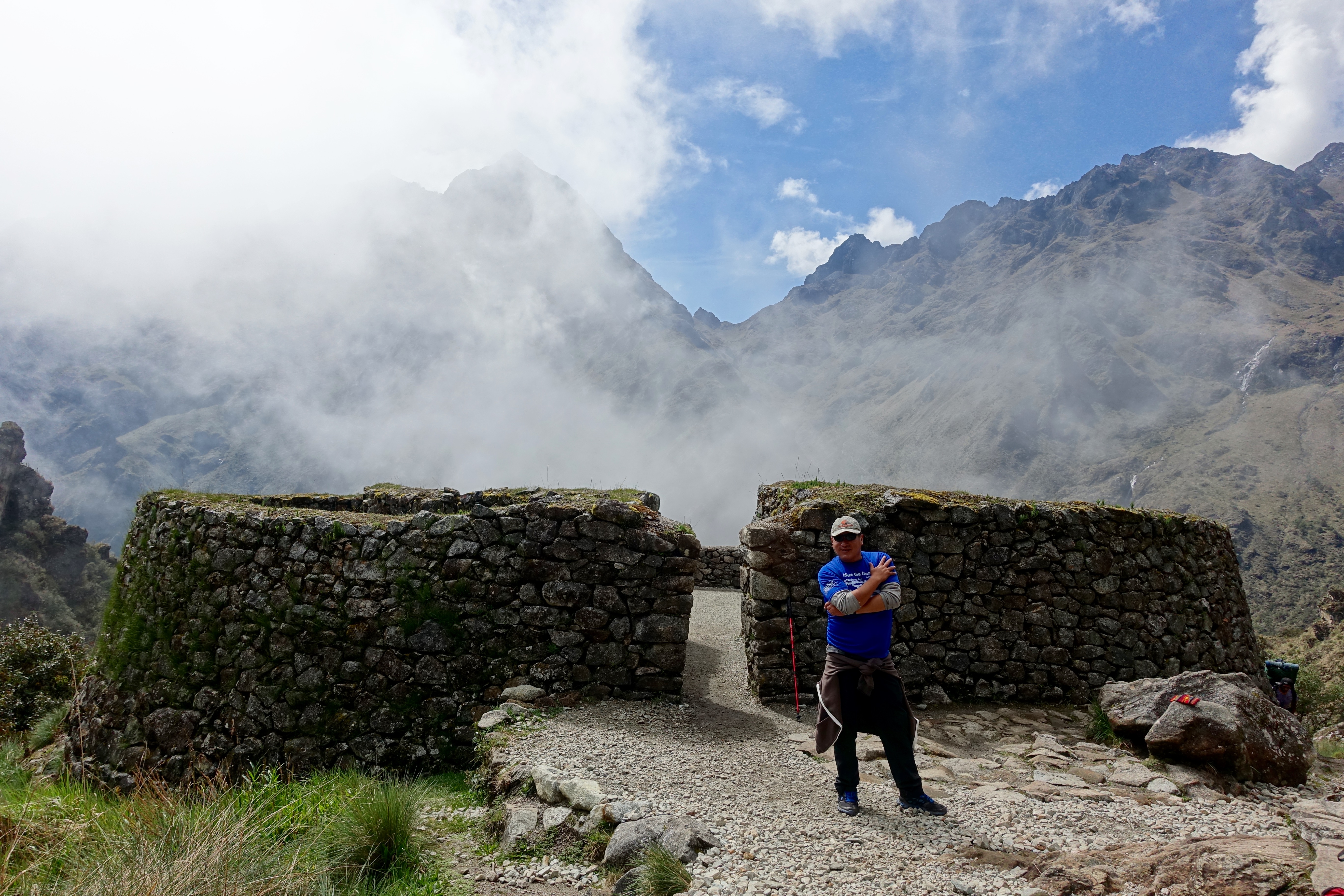
 It was then time for us to shoulder our packs on and head out. For about 45 mins the stroll to Huayllabamba was much like the day before, soon after however, we began a gradual uphill climb to Ayapata that took about an hour. Ahead of us was the infamous Dead Woman’s Pass. Day 2 of the hike is said to be the most challenging, all of us knew it was coming, but we couldn’t help but be apprehensive about the struggles we would face. Thankfully it was split up into two parts.

Tom looking exhausted.
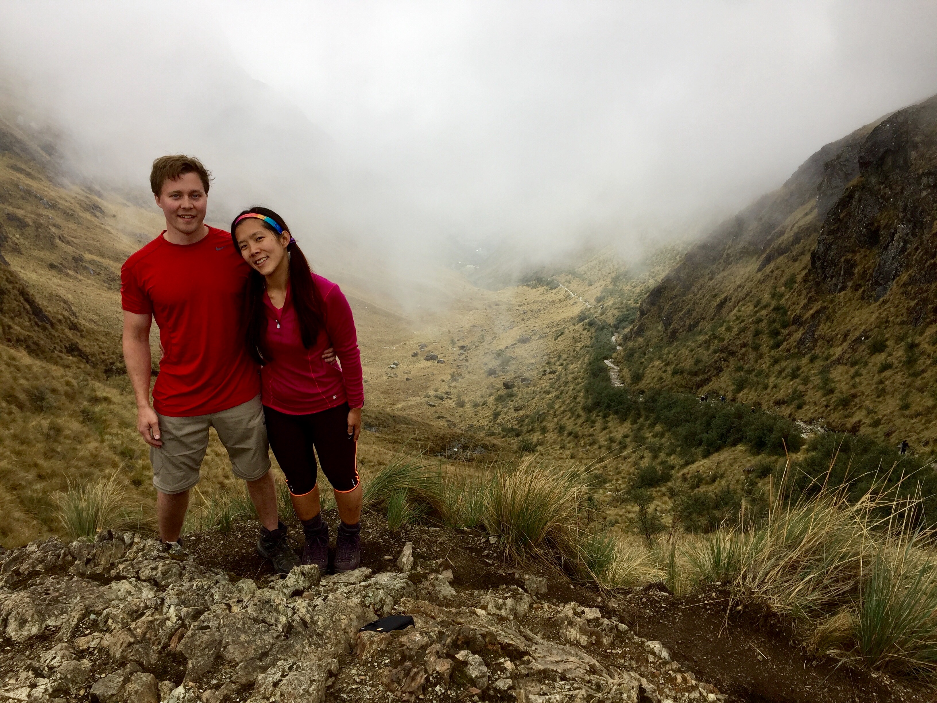
As our climb up the old Inca Stone steps became steeper, our pace became slower. I tended to be at the back of the pack because I had learned that I didn’t want to push myself too fast, and I’m not exactly the most steady-footed individual. (Not to mention, that one of our trek-mates, Harry, had pushed himself the day before to keep up with his twin brother, and ended up feeling really lightheaded at last night’s dinner and needed to take a dose of oxygen including all the miscellaneous coca leaves and altitude medications we tossed his way). It was much wiser, and better, to take it slow and steady like the tortoise and pause for breathing breaks and water as needed. I gave myself plenty of time to enjoy the scenery and look around, while Tom forged on ahead.

Seeing all the snow-capped peaks (incl. Apu Huayanay Mountain) around us was breathtaking! The views on the way up were spectacular, and I couldn’t stop myself from snapping pictures of flowers left and right. We also heard and saw some hummingbirds, but they flit around so fast it’s impossible to snap them!
After about 3 hours, we reached the Llulluchapampa Valley for our lunch break. It also started drizzling while we ate and we were all worried that we would be hiking in the rain! Fortunately, the time we took for lunch, including the typical siesta “break” was just enough for the rain to stop and the skies to clear. (This also meant that it wasn’t dry enough for us to lay out and close our eyes for a rest)
 It was then time for Leg 2 of our ascent. The higher we climbed, the less sun we saw because we were literally climbing into a forest of clouds! The tree line fell away and we began to be surrounded by Polylepis Woodlands overflowing with grasslands speckled with small Andean bushes. It also began to get colder, and more demanding on our cardiovascular systems, so the rate of our pauses increased. Since a large portion of the steps were reconstructed, they were deeper than the older Incan steps, and I found myself occasionally having to haul my body and pack up steps that were almost 2X the modern tread depth! I acquired a newfound appreciation for my hiking poles.
 After roughly 3 hours we reached the peak, the “belly” of Dead Woman’s Pass! We had somehow managed to ascend 1,200 meters (~ 4,000 ft) within a span of 5-6 hours, and were standing at an elevation of 4,200 meters (~13,000 ft). We were so thrilled with our accomplishment, and the tenacity with which we pushed through the climb. Unfortunately, since I was at the back of the pack the clouds had moved in just before I summitted so I was not able to enjoy the scenic view of the valleys below us.

I enjoyed the descent into the Pacaymayo Valley significantly less, namely not at all. At that point my knees were starting to hurt, so I was going slower, and the combination of clouds and fog made visibility difficult. At one point I couldn’t see anyone in front of me or behind me and I was so scared that no one would be nearby if I slipped and fell. :(. When I finally found Tom I was obviously not happy with him. I had told him to forge on ahead on the uphill, but I felt that he should have known that the downhill would be my weakness. I wanted him by me for support and company, even if it required him to slow down his pace. After a burst of anger and tears, we continued on our way and made it to camp and settled down for the night. It took awhile for my steam to wear off….
Tom ended up having a splitting headache as well, and despite his generous dosage of pain medication, the guides made him take a few doses of oxygen as well.
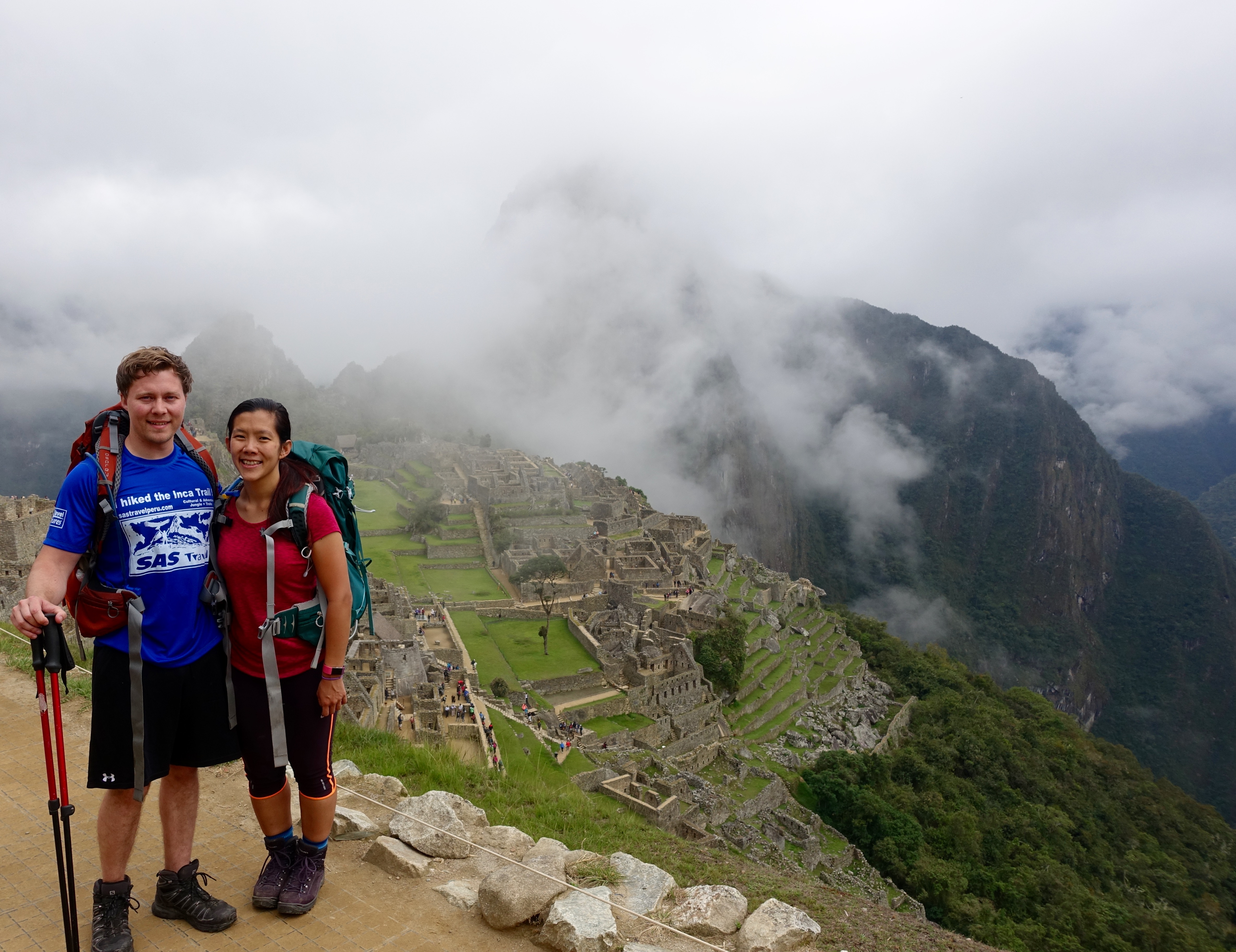
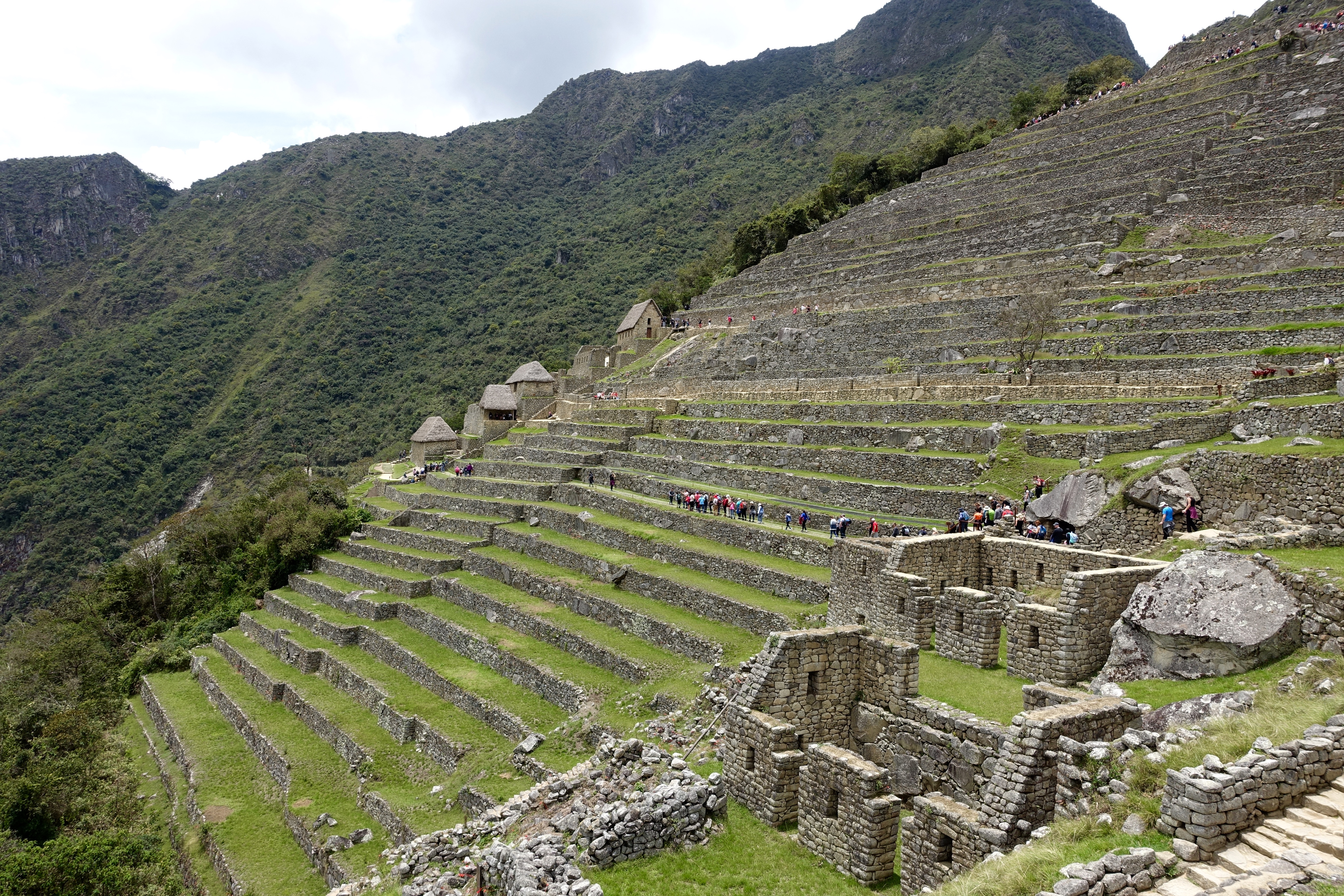
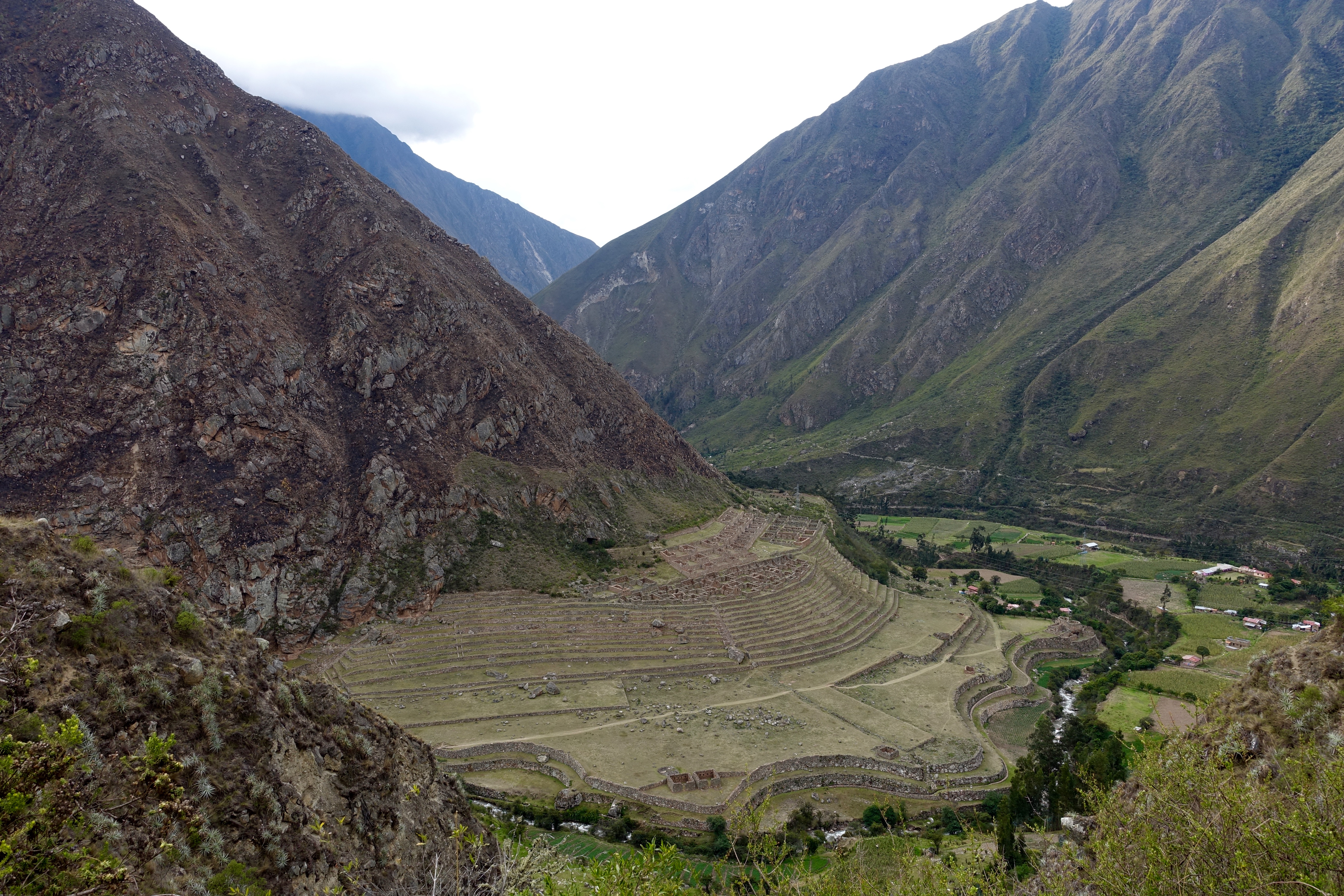
 After Freddy concluded our tour yesterday, we were given some free time to roam around the Incan city before having to meet the rest of the group for lunch in Aguas Calientes. There are only two “directional path” options to take, so we took the route that we had not already traversed, climbing upwards for a better vantage point of the complex.
 A few of our group members actually raced back to the sun gate (Intipunku) since the skies had cleared of the cloudiness from earlier. (Tom and I opted not to do this since a) I’m slow and b) We thought the view would be underwhelming.
 At lunch we were very disappointed to discover that our train and subsequent bus back to Cusco would not have us arriving until 10 or 11 PM which was far later than the advertised typical time of 8 PM, especially considering the fact that we had woken up at 3:30 AM. We ended up having to burn about 4-hrs of time just drinking, chatting, and roaming aimlessly. By the time we got back to the city, after a 2-hr train ride followed by a 2-hr bus ride (requiring a baño ecologíco stop for everyone that had been drinking), we were completely drained.
 About 10-mins later Tom and were very unhappy to find out that the Pariwana Cusco Hostel, whom we had made reservations with over the phone when we stayed at their sister hostel, Pariwana Lima, had absolutely no record of our reservation! Nor did they have any private, double rooms available! We were both beyond pissed as they only had dormitory beds available and did not offer any viable alternatives for us. The last thing we wanted to do after a 4-day hike was to share a room with strangers that would very likely compromise our sleep.
  Fortunately, Milhouse Hostel, who we had stayed with before we left for our hike did have the availability we were looking for, and was just around the corner. (Note to self: I still need to leave the negative review for Pariwana).
 Originally, we had both been thinking of buying either a lute or flute from Sabino Huaman (one of only two luthiers in all of Peru, and whose small shop we accidentally stumbled across before we left for our hike), but we decided that while conceptually it would be a unique item to own, it was not a necessary souvenir….and our legs were so so tired.