Lima: Before The Incas

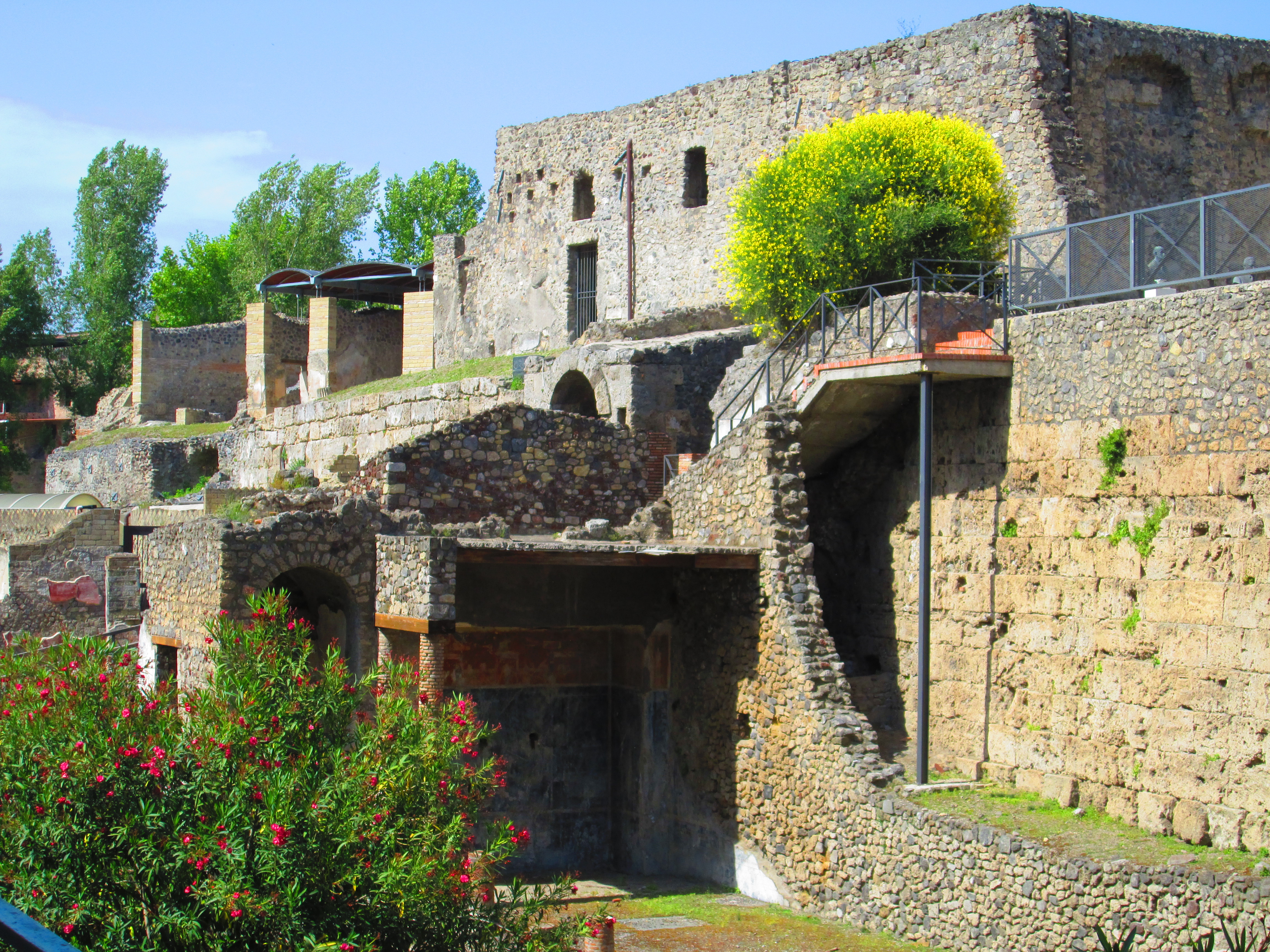
Before the Inca Civilization became so pervasive in the 16th century, with origins dating from the 13th century, a multitude of ancient civilizations preceded it. We explored the history behind a number of these societies with our first stop of the day, Huaca Pullcana.

Huacca Pullcana is a great adobe and clay pyramid in the Miraflores district of Lima. It is built of seven staggered platforms and served as the ceremonial and administrative center of the Lima Culture. The complex, now diminished from its original extents due to urbanized construction and disrespect for the value of history, is surrounded by a plaza with a large structured wall dividing the sections. 

The Lima’s main source of sustenance came from the sea and the land. This is exemplified by excavated deep pits that show evidence of fish and marine life being used as offerings. Young girls between the ages of 15-25 were also used as sacrifices to the gods (thankfully I have already passed the age cut-off). The pyramid provided a location for these offerings, and once space became scarce or a new generation arose, a new terrace was built directly above the former one.

As the layers were built-up over a long period of time, roughly every 15-20 years, the evolution of brick design is easily seen. Interestingly, instead of being stacked horizontally, they were stacked vertically with an air gap between each brick. It is believed that these air gaps were left in order to allow the pyramid to “rock” when an earthquake hit. As a structural engineer I thought that this was pretty cool! The Lima Culture had essentially designed their very own basic, but assumedly effective , earthquake proof building. (Essentially a fixed base with a very flexible structure)

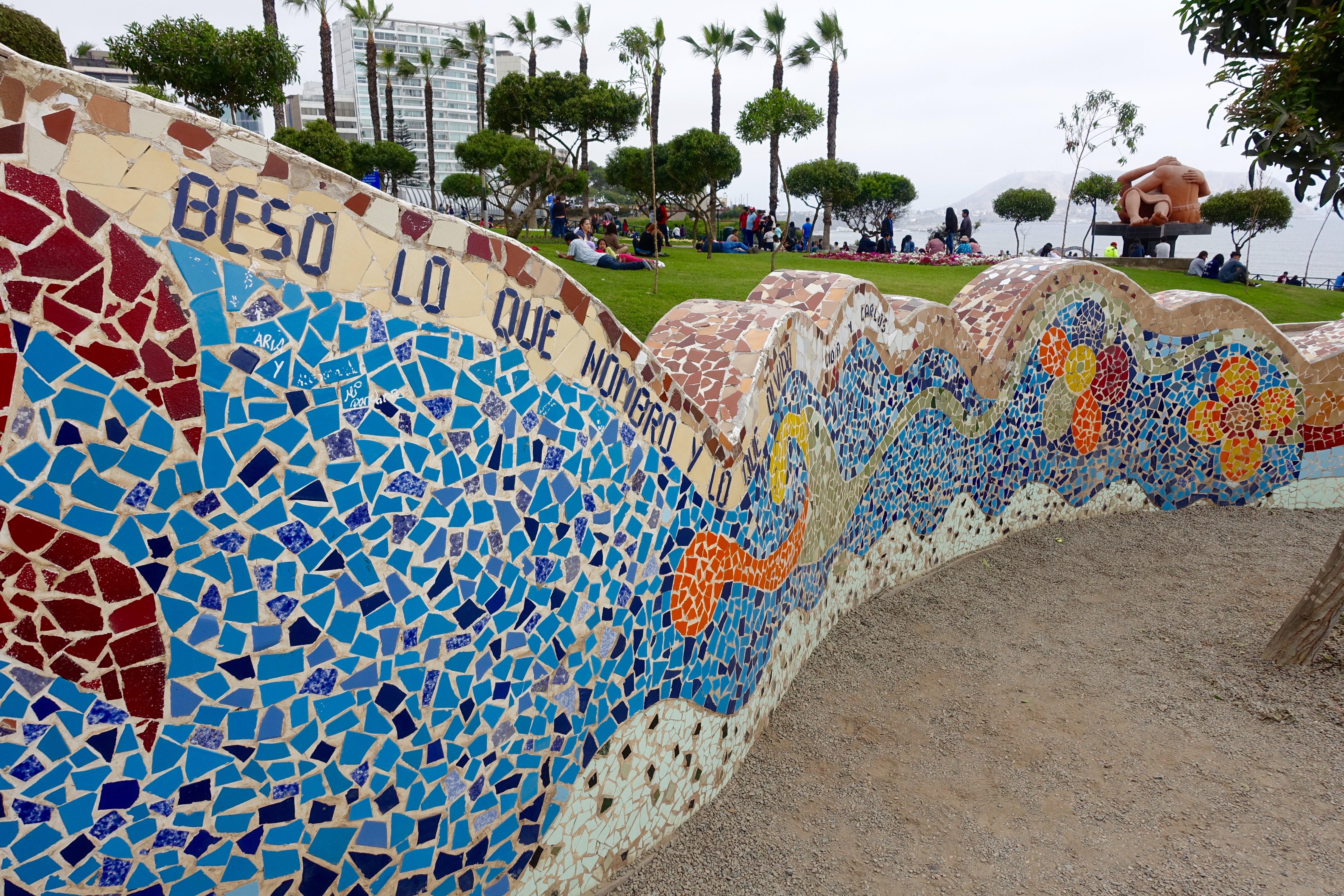
After visiting the archeological site, we returned to our hotel to check out and switch over to a nearby hostel. We then grabbed lunch at La Lucha Sangucheria (Again!) before heading for a stroll along the cliffs to see the beach and visit El Parque de Amor, Love Park. The park is said to have been inspired by Park Guell in Barcelona. It features a sculpture called “El Beso,” which is said to depict the artist, Víctor Delfín, and his wife kissing. 

I tried to get Tom to kiss me in front of the sculpture and selfie it. Unfortunately he refused on the grounds that it was too cliche. :(. Honestly I was happy that I was able to get him to agree to a selfie at all! I blame him for why most photos I post contain no traces of him or even myself. I swear that it is like pulling teeth.

After walking along the cliffs for a few hours, with a stop to watch the paragliders lift off and land high into the sky and one to roam the Larcomer Shopping center (including a pit stop), we returned back to our hostel for a brief reprieve. 

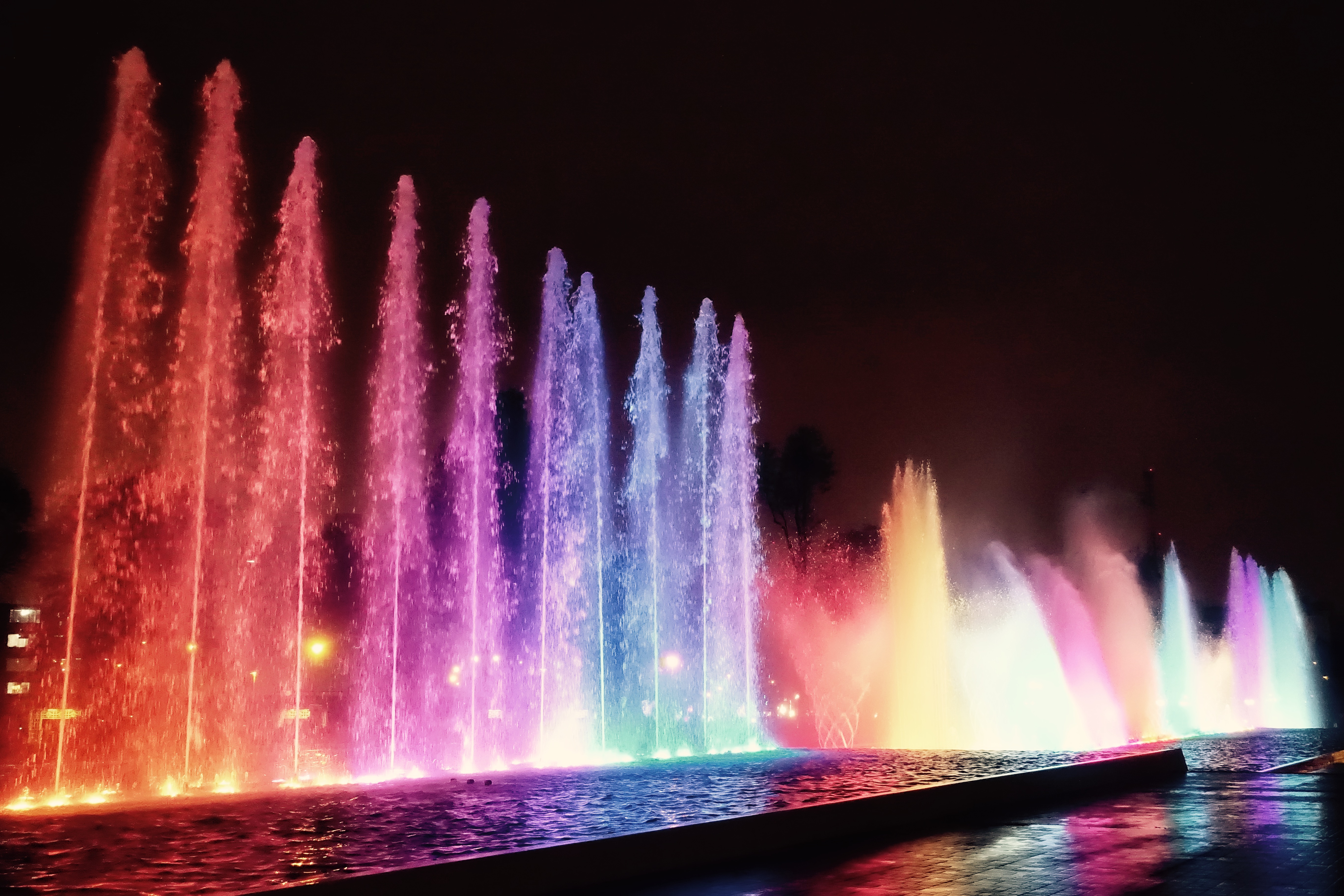
Our feet somewhat rested after an hour or so, we caught the bus to visit the Park of the Reserve and the Magic Water Circuit. The park is the current world record holder for the largest fountain complex in the world and is home to 13 distinct and interactive fountains with ever changing color schemes. 

We arrived just in time to watch the main show at the Fountain of Fantasy which included projections onto the misting water, moving animals and shapes made by 3-dimensional layers, and of course, synchronized streams of water shooting left and right to synchronized music. After that, we visited the other 12 fountains and stopped at a vendor to try some Picarones, a squash and sweet potato donut covered in molasses syrup. 

After a long day, with over 28,0000 FitBit steps, we returned to our hostel to grab dinner, after which Tom promptly passed out while I stayed up to diligently write my blog. 🙂 


Oslo: City of Tigers II

In 1870, Bjørnstjerne Bjørnson wrote a poem titled , “Sidste Sang”. In it, he illustrates a dramatic fight between a horse and a tiger. The tiger, metaphorically represented the dangerous city, while the horse symbolized the security of the countryside. This is where he first referred to Oslo as Tigerstaden, which represented his perception of the city as a cold and dangerous place. 

 This has not been the case for Tom and I. We have found this snowy, northern city to be warm and friendly. Our barista from earlier this morning graciously gave us a list of restaurants to eat at, and even attempted to teach me the word for “thanks” in Norwegian, “Taak”. (I hope I haven’t been butchering the word too much, but I always like to learn how to say “please” and “thank you” when I travel. I’ve found it is a simple way to show your enthusiasm for the local history and, even though they may laugh, the locals often appreciate your effort.) 

 Making use of one of the barista’s recommendations, we ventured towards Aker Brygge, a unique, waterfront development that was completed in 2014. It was formerly the site of a shipyard and industrial buildings. Vingen, a restaurant attached to the Astrup Fearnley Museet was difficult to find, but incredibly tasty! Tom had the Eggs Benedict, while I had their version of a Katz Pastrami Sandwich.

 After a brief break, we ventured back into the cold to explore the history of the Akershus Fortress. Construction of the fortress is believed to have started around 1290 when King Hakon V realized that the city needed a stronger defense center than that which currently existed. Since it lied adjacent to the sea, it allowed Norway to prosper commercially while providing the nation with a strong military presence. 

 The Akershus Fortress has never been successfully besieged by a foreign enemy. However, in 1940, it surrendered to Nazi Germany without combat. The Norwegian government evacuated the capital when it was unprovokedly assaulted.

  
Our feet getting wary, we decided to make our last stop for the day before heading back to the hostel to rest our laurels. The Oslo Opera House is uniquely designed such that the roof of the structure angles to the ground level. This creates an elevated plaza that allows pedestrian interaction with the building. Tom and I climbed all the way up and were greeted with a panoramic view of the waterfront.

As a structural engineer,the fact that this roof is merely supported by thin angled columns is intriguing. How, exactly did they analyze the load paths/patterns through the asymmetrical characteristics of the column geometry?  The minimalistic framing and specialty glass allows for optimal views of the surrounding water. 

 From the roof, and at ground level, we observed the sculpture, “She Lies.” The stainless steel and glass fabrication resembles ice and depicts a symbol of power for the region. As it lays on a transient concrete platform, it is free to turn with the bidding of the tide and the wind. I think the sculpture is a metaphor. For as quick as the tides change and the wind changes direction, so too can the power shift.  

P.S. Tom is currently passed out next to me. If anything, my boyfriend could certainly hibernate through a long winter if instinct required it of him. 😛

Travel: Sleepers and Bazaars

After Ranthambore, Nick and I had booked a night train to our next city, Jodhpur.

imageAs has often been the case, we were woefully unprepared for how basic the sleeper cabins were. Unlike trains in Europe, you are only provided a cot. It was only after we found our berths that it dawned on us why so many people on our platform had brought pillows and blankets.


Needless to say, it was the coldest night we’ve had. The train windows are openly ventilated, and despite putting on all our layers, time passed slowly. I’m pretty sure I contracted a cold because of this. 😦

image


Jodhpur is known by two names, the “Sun City” for the year-round sunny weather, and the “Blue City” due to the uniquely blue houses that surround the fort. It is the second largest city in Rajasthan, and was formerly the capital of the Marwar Kingdom.


imageNick and I were not up for much after we finally arrived at our hotel. It was also the King’s Birthday (royalty still resides in the palace) so all of the major tourist attractions happened to be shut down. We opted to visit the Ghanta Ghar “Clock Tower,” and roam the nearby Sadar Bazaar to make a second attempt at finding me a Saree.

image


It took quite a bit of negotiating, but we finally found a shop that had all the pieces and would measure me so that it would be a custom-fit. We then proceeded to buy all the requisite shoes and jewelry to match this outfit before heading back to the hotel for dinner and an early night.

Travel: Old Jaipur

To recap thus far, we have visited the states of Delhi – the capital territory of India – and Madhya Pradesh – “the heart of India” – and are now exploring Jaipur, the capital city of Rajasthan.

imageJaipur was founded by Jai Sing II, the Raja of Amer in 1727. His capitol originally lay 51 km away, but water was becoming scarce, and Jai felt that shifting his city would increase the population. After much deliberation and the architectural guidance of Vidyadhar Bhattacharya, the city was laid-out in accordance with the classic principles of Vastu Shastra. Its core concept centers around urban planning for the comfort of its citizens and the integration of the built environment with nature, while trying to maintain perfect geometric patterns (Yantra), symmetry, and directional alignment.

image

Credit: Nikhil Kulkarni

The first stop of our day was the Hawa Mahal, “Palace of Winds.” Built in 1799 by the Maharaja Sawai Pratap Singh, the structure was designed by Lal Chand Ustad to form the crown of Krishna. The five-story exterior face is reminiscent of the honeycombs of a beehive, and has 953 jharokhas (small windows) with intricate latticework. Not only did the windows allow royal ladies to observe daily life without being seen, but it also resulted in the Venturi Effect, natural ventilation that helped promote the flow of cool air through the building in the summers.

imageI also noticed that a lot of the window slots slanted downwards. Jaipur, named “The Pink City” because so many of its buildings are painted pink, lies in the desert. The slant of the window perforations allowed residents access to fresh air, without putting them at the mercy of the blazing sun. I found this to be a particularly ingenious idea for being created almost 300 years ago.

We had then hoped to visit the City Palace, but were rebuffed by how expensive it would have been to tour the interior (about 2500 rupees for foreigners with no cameras allowed).

imageWhile the pictures shown at the ticket office were pretty jaw dropping, this price point would have been equivalent to $45! It would have been the most expensive tourist destination I’d ever gone to across every continent and country. At the same time, this is marginally understandable as Rajasthan is one of the few states with present-day Royalty. They only chose to merge with the Indian Union after Indian Independence in 1949.

Credit: Nikhil Kulkarni

Credit: Nikhil Kulkarni

Just a few steps away was the Juntar Mantar. You may recall that it has a sister that we visited in Delhi.


Travel: In the Steps of Michaelangelo

English: Capitoline Hill, Rome. Image:Fratelli...

Before we could enter the Roman Ruins that day, my new friend and I stumbled upon the tail-end of a parade in celebration of some unknown national holiday. I’m still not clear on what it was, but I would have been thrilled if I had managed to catch sight of all the festivities. Unfortunately for us, we discovered that it delayed the opening of our attractions for the day. Rather than being open that morning, neither the Imperial Forum, nor the Colosseum were going to open until that afternoon. Instead, we took a long stroll around Capitoline Hill, one of the seven hills of Rome and the original Citadel of the first generation.

The Abduction of the Sabine Women, by Nicolas ...

It is at this site that the Sabines, were granted access by the Roman maiden Tarpeia. For her treachery, she was the first to be flung from a steep cliff overlooking the Roman Forum. Later named the Tarpeian Rock after the Vestal Virgin, it became a frequent execution site.

The first Sabines immigrated to Rome following the Rape of the Sabine Women.

You may recall an earlier post from the beginning of my trip when I went to visit the Fatima Sanctuary, the following brings to mind how individuals can be so devout to subject themselves to pain in the name of their faith. Legend says that  Julius Caesar approached the foot of the hill and Jupiter’s Temple on his knees in penance for his actions in the civil wars and to avert an unlucky omen of Jupiter’s wrath. He was moved to do so after he suffered an accident during one of his triumphs. Despite this, he was murdered six months later, and Brutus and his conspirators barricade themselves within the temple.

Excuse me, I’ve gotten a bit off track from my original topic., back to Michelangelo!

What I’ve come to love about Rome are the subtle nuances that pervade every cornerstone and recess of its ancient culture and architecture. A prime example of this is the Piazza del Campidoglio.

Michelangelo's design for Capitoline Hill, now...

In his prime, he was commissioned by the Farnese Pope Paul III to design a plaza. The Pope wanted a symbol of the new Rome to impress Charles V, who was expected in 1538. Having an opportunity to build such a monumental civic space, granted Michelangelo the opportunity to make a resonating statement reestablishing the grandeur of Rome.  His initial designs for the Piazza date from 1536 and were formidably extensive.

In an emblematic display, he chose to accentuate the reversal of the classic orientation of the Capitoline. Instead, the gesture turned Rome’s civic center away from the ancient Roman Forum  to face the direction of Papal Rome and the Christian church  represented by  St. Peter’s Basilica.

2013-06-02 05.01.33

His made a bold metaphorical statement:

“This full half circle turn can also be seen as Michelangelo’s desire to address the new, developing section of the city rather than the ancient ruins of the past.” ~In the wise words of Wikipedia

I have so much more I want to say about how Michelangelo used his ingenuity to address problems such as a sloped site and the lack of building facades facing each other squarely, however, I will leave that to your research. The structural engineer in me is trying her hardest not to bore you with devious architectural solutions.

Travel: Vesuvius and Pompeii

Today, I finally achieved my goal of hiking along the side of an active volcano, and exploring a two-millennia old roman village. We will get to the emotions ignite later. Getting there was a challenge, however, because they shut down the metro system without any notice. I was forced to cram myself into two different buses (transfer) so that I could reach the train station. What should have taken a mere half hour, ended up in consuming an hour and a half of my morning. 😦

2013-05-28 04.47.14

Finally, I arrived on Mt. Vesuvius, after getting to the Ercolano Train station, and hopping a 20-min shuttle drive up the side. I won’t lie, it was a little anticlimactic for me. The 30-min hike up the rim was steep, but riddled with gravel and dust, and no protection from the beating sun. The rim of the volcanic crater slopped off into this massive hole with disproportionate sides, sparse vegetation, and nothing close to an imposing atmosphere.

2013-05-28 05.17.24

The volcano is best known for it eruption in AD 79 that completely smothered and buried the Roman cities of Pompeii and Herculaneum. The activity ejected a sprawling cloud of stonesash, and fumes to a height of 20.5 miles; Molten rock and pulverized pumice were spewed at a rate of 1.5 million tons/sec, releasing a 100,000x the thermal energy released by the Hiroshima Bombing.

Today, it is on only volcano on the european mainland to have erupted within the last hundred years. It is regarded as one of the most dangerous in the world due to the dense population of 3,000,000 people and its tendency towards explosive (Plinian) eruptions.

2013-05-28 08.56.19

Descending from the volcanic slopes, I hopped a train to reach my next destination. Unfortunately, the signage was not clear, and it took a bit longer due to having to hop off and go back in the former direction. I did meet two british teachers who were on holiday for the season, and we enjoyed a very nice chat about employment and careers. Somehow I always manage to converse with kindly middle-aged people; I just have that kind of personality.

2013-05-28 09.19.11

Arriving at the Pompeii Scavi, it is difficult to describe how much square footage this city encompasses. It is believed that the town was founded in 6th or 7th century BC and was captured by the romans in 80 BC. When it was destroyed 160 years later, the population had exploded to 20,000 with a complex water system, amphitheatre, gymnasium, and a port.

Evidence indicating the destruction comes from a surviving account from a letter written by Pliny the Younger. He saw a firsthand account of the eruption from a distance across the bay, and described the death of his uncle, Pliny the Elder, an admiral of the Roman fleet who tried to rescue citizens. The site was then lost for 1500 years before being rediscovered in 1599. Buried objects have been well-preserved for thousands of years due to the lack of air and moisture.

The  Pax Romana civilization was extremely intelligent in their urban design:

2013-05-28 09.06.46

White Marble to reflect the moonlight, so citizens could walk the streets at night.

2013-05-28 12.16.21


Raised stones, so citizens could cross the streets above the much of animal refuse and garbage.


2013-05-28 11.24.46


The first documented brothel in the world. (Okay, maybe not innovative, but certainly a historical achievement).


At the end of the day, I just couldn’t get over the fact that it was these humble two feet, that traipsed across the streets of a centuries old city riddled with heritage and tragedy.2013-05-28 10.50.57